White Rim trip
Apr. 26th, 2013 06:13 pmThe White Rim Trail is a well-known 4WD road approximately 100 miles long which loops between the Colorado and Green Rivers through Canyonlands National Park near Moab, Utah: it descends from the 'Island In The Sky' mesa top down to the level of the White Rim sandstone, which was formed during the Permian period 245 to 286 million years ago. Blah blah blah, a picture's worth a thousand words:

(Okay, I'm cheating here, because I'm not riding on the actual trail but on the sandstone rim. Most of the ride is really not as scary as this makes it look!)
The White Rim is popular with jeep drivers, motorcycle riders, and cyclists. Cyclists who are real hardmen do it in one day, sometimes even, as one couple Britt chatted briefly with, on singlespeeds. (Which, holy shit. Apparently they started at 3:30am!) Slackers like us, on the other hand, do it as a three-night camping trip with 4WD support (as there is no water available on the route). Our group of fourteen (all but one from Colorado, all but three - oddly - women) had three 4WD pickup trucks for support, and each of us alternated biking, driving, and (occasionally, for a few of us) running.
Britt and I had ridden the White Rim twice before, in the 1990s, and both times we had gone counter-clockwise. This ride was to be clockwise, which is apparently recommended as it makes the sandy sections generally downhill (and therefore easier) and the third night's camp is on the Green River, convenient for washing off accumulated sweat and grime.
After shuttling all but the support vehicles to the intersection of the road into Island In The Sky and the Mineral Bottom road (this cuts off ~8 miles of pavement from the ride) we descended the mindboggling switchbacks of the Shafer Trail.


The first interesting side-trip is Musselman Arch, which is a flat natural bridge in the White Rim sandstone layer perhaps four feet wide at its narrowest. It tends to disappear into the landscape in pictures, but we posed on it anyway:


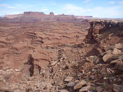
It was beautiful riding on the sandstone rim. When the road curved, we could see networks of red rock side canyons, and arches and pillars, and in the distance we occasionally caught glimpses of the Colorado river beyond.

We camped at one of the Airport campsites (it's directly under Airport Mesa, which according to one source looks like an ATC tower, but another claims a small plane once landed on it); the group at another of the campsites had a Sportsmobile as one of their support vehicles, so naturally Britt and I had to go over and look at it and introduce ourselves as owners. Back at our own camp, we set up our tent but decided against putting up the rainfly, as it was fairly warm. This apparently caused it to start raining at around 5am, and we had to get up and hurriedly put the fly on and get our gear under cover, along with most of the rest of our group who had also been rather lackadaisical about the weather.
It rained a bit the next morning, too, and so we assembled as many layers of clothing on us as there were rock layers in Canyonlands, or so it seemed to us. We took a late lunch at the White Crack campsite, a mile or so out from the main rim road, then walked out to the rocks that give White Crack its name. Britt and I and a few of the others explored below the rim level, where the softer red rock cuts back away from the harder rim rock, forming a nifty little window.


And then some of the group gave White Crack its name in an entirely different way....

(Not me! I am in the blue shirt watching the, er, crackers!)
We camped on top of Murphy Hogback, after a grueling climb. We made sure to put the fly on the tent, just in case. Naturally, it was a beautifully clear night.
The next morning I decided to take my turn as driver to the lunch spot at the Holeman Slot (a short slot canyon we'd explored on previous trips) and then put on my running shoes and run, rather than bike, the 10.5 miles to the Fort Bottom trail. It would still be a couple of miles to our camp, but I'd get a lift from Britt, who would be the afternoon driver - I hadn't run over 8 miles since my half marathon in March, and I didn't want to push things.
I actually hadn't planned on doing any running at all (the running shoes were along for walking purposes) but one of the other women on the trip, Kara, is an ultrarunner, and had stated her intention to run rather than bike much of the distance. She'd driven the first day, then run a side trail to the river and back, an 8-mile round trip; the second day she ran the 21 miles (!) from Airport to White Crack, and we ran together this afternoon. It was much more fun than I would have thought, considering it was pretty much just a jeep road. We ran nice and easy, slowed by the afternoon heat, chatting with each other and waving as one by one, the bikes passed us. (But we got our revenge on the last long, hard uphill - it's a lot faster to hike uphill without a bike!)
Last two pictures are Anna and Allen looking down the Black Crack, an apparently bottomless crevice we stopped at for a snack, and a bunch of us hiking back from Fort Bottom:


Yep, after 10.5 miles of running I walked another 3 miles round trip with some of the group - Kara kept going to camp - and then I rode with Britt the rest of the way to the Hardscrabble campsite. We 'washed', more or less, in the OMG EXTREMELY COLD Green River before dinner, and I have to say, it was nice to get some of the sweat off, but OMG EXTREMELY COLD.
In the morning we got ourselves packed up relatively early and headed out on the last leg. The first part was sandy, with a few small up and downhills but nothing major. Then after a snack break it was up-up-up the Mineral Bottom road, a fairly good 2WD dirt road; it had been patched and shored up after washing out a few years back, and although it was a serious grind (not quite a thousand feet up in a mile and a half of switchbacks) both Britt and I managed to ride up without stopping. One of our support trucks was parked at the top of the climb, and there was cold beer in its cooler, and wow, did that ever taste GOOD. It would have given us the strength to do what needed to be done, viz., ride the last 12 miles to where the rest of the cars were parked, but you know what? It was uphill, and windy, and Britt had given his keys to one of that day's drivers, who had taken one of the first arrivals up to the parking lot. We had only ridden a mile or so when our van appeared over a hill, and we decided that would be the end of our ride.
In sum: AWESOME. And I want to do it again.
(Okay, I'm cheating here, because I'm not riding on the actual trail but on the sandstone rim. Most of the ride is really not as scary as this makes it look!)
The White Rim is popular with jeep drivers, motorcycle riders, and cyclists. Cyclists who are real hardmen do it in one day, sometimes even, as one couple Britt chatted briefly with, on singlespeeds. (Which, holy shit. Apparently they started at 3:30am!) Slackers like us, on the other hand, do it as a three-night camping trip with 4WD support (as there is no water available on the route). Our group of fourteen (all but one from Colorado, all but three - oddly - women) had three 4WD pickup trucks for support, and each of us alternated biking, driving, and (occasionally, for a few of us) running.
Britt and I had ridden the White Rim twice before, in the 1990s, and both times we had gone counter-clockwise. This ride was to be clockwise, which is apparently recommended as it makes the sandy sections generally downhill (and therefore easier) and the third night's camp is on the Green River, convenient for washing off accumulated sweat and grime.
After shuttling all but the support vehicles to the intersection of the road into Island In The Sky and the Mineral Bottom road (this cuts off ~8 miles of pavement from the ride) we descended the mindboggling switchbacks of the Shafer Trail.
The first interesting side-trip is Musselman Arch, which is a flat natural bridge in the White Rim sandstone layer perhaps four feet wide at its narrowest. It tends to disappear into the landscape in pictures, but we posed on it anyway:
It was beautiful riding on the sandstone rim. When the road curved, we could see networks of red rock side canyons, and arches and pillars, and in the distance we occasionally caught glimpses of the Colorado river beyond.
We camped at one of the Airport campsites (it's directly under Airport Mesa, which according to one source looks like an ATC tower, but another claims a small plane once landed on it); the group at another of the campsites had a Sportsmobile as one of their support vehicles, so naturally Britt and I had to go over and look at it and introduce ourselves as owners. Back at our own camp, we set up our tent but decided against putting up the rainfly, as it was fairly warm. This apparently caused it to start raining at around 5am, and we had to get up and hurriedly put the fly on and get our gear under cover, along with most of the rest of our group who had also been rather lackadaisical about the weather.
It rained a bit the next morning, too, and so we assembled as many layers of clothing on us as there were rock layers in Canyonlands, or so it seemed to us. We took a late lunch at the White Crack campsite, a mile or so out from the main rim road, then walked out to the rocks that give White Crack its name. Britt and I and a few of the others explored below the rim level, where the softer red rock cuts back away from the harder rim rock, forming a nifty little window.
And then some of the group gave White Crack its name in an entirely different way....
(Not me! I am in the blue shirt watching the, er, crackers!)
We camped on top of Murphy Hogback, after a grueling climb. We made sure to put the fly on the tent, just in case. Naturally, it was a beautifully clear night.
The next morning I decided to take my turn as driver to the lunch spot at the Holeman Slot (a short slot canyon we'd explored on previous trips) and then put on my running shoes and run, rather than bike, the 10.5 miles to the Fort Bottom trail. It would still be a couple of miles to our camp, but I'd get a lift from Britt, who would be the afternoon driver - I hadn't run over 8 miles since my half marathon in March, and I didn't want to push things.
I actually hadn't planned on doing any running at all (the running shoes were along for walking purposes) but one of the other women on the trip, Kara, is an ultrarunner, and had stated her intention to run rather than bike much of the distance. She'd driven the first day, then run a side trail to the river and back, an 8-mile round trip; the second day she ran the 21 miles (!) from Airport to White Crack, and we ran together this afternoon. It was much more fun than I would have thought, considering it was pretty much just a jeep road. We ran nice and easy, slowed by the afternoon heat, chatting with each other and waving as one by one, the bikes passed us. (But we got our revenge on the last long, hard uphill - it's a lot faster to hike uphill without a bike!)
Last two pictures are Anna and Allen looking down the Black Crack, an apparently bottomless crevice we stopped at for a snack, and a bunch of us hiking back from Fort Bottom:
Yep, after 10.5 miles of running I walked another 3 miles round trip with some of the group - Kara kept going to camp - and then I rode with Britt the rest of the way to the Hardscrabble campsite. We 'washed', more or less, in the OMG EXTREMELY COLD Green River before dinner, and I have to say, it was nice to get some of the sweat off, but OMG EXTREMELY COLD.
In the morning we got ourselves packed up relatively early and headed out on the last leg. The first part was sandy, with a few small up and downhills but nothing major. Then after a snack break it was up-up-up the Mineral Bottom road, a fairly good 2WD dirt road; it had been patched and shored up after washing out a few years back, and although it was a serious grind (not quite a thousand feet up in a mile and a half of switchbacks) both Britt and I managed to ride up without stopping. One of our support trucks was parked at the top of the climb, and there was cold beer in its cooler, and wow, did that ever taste GOOD. It would have given us the strength to do what needed to be done, viz., ride the last 12 miles to where the rest of the cars were parked, but you know what? It was uphill, and windy, and Britt had given his keys to one of that day's drivers, who had taken one of the first arrivals up to the parking lot. We had only ridden a mile or so when our van appeared over a hill, and we decided that would be the end of our ride.
In sum: AWESOME. And I want to do it again.
(no subject)
Date: 2013-04-27 05:06 am (UTC)But beautiful - eee, I was at Arches, yonks ago! Sounds like a great, fun trip.
Singlespeeds?? How do they not mess up their knees ;_; ?
(no subject)
Date: 2013-04-28 01:13 am (UTC)I was thinking about putting a "WARNING: MOM, DON'T LOOK!" on this post... :-)
(no subject)
Date: 2013-04-27 08:03 am (UTC)Those landscapes are gorgeous. Looks like the Negev desert here, except about 30,000 times bigger.
(no subject)
Date: 2013-04-28 01:51 am (UTC)(And I duly pointed it out to Kara, saying, "Look! Penis Rock!" which made her crack up and swear that she'd never be able to look at it again without thinking of penises...I felt like I'd accomplished something positive!)
I was in the Negev ages ago *is old* and only remember it vaguely. And that was before I moved to the western US, so no comparisons in my mind, really. I'll have to dig out my old photos!
(no subject)
Date: 2013-04-28 03:05 am (UTC)The Negev is great and I'd love to go cycling/hiking there, except in the summer it's incredibly hot and in the winter you get flash-floods that randomly drown people. So... I haven't managed it yet!
(no subject)
Date: 2013-04-27 04:42 pm (UTC)(no subject)
Date: 2013-04-28 01:51 am (UTC)(no subject)
Date: 2013-04-28 12:28 am (UTC)(no subject)
Date: 2013-04-28 01:58 am (UTC)(no subject)
Date: 2013-04-28 02:19 am (UTC)I realised during the week that the steepest hill near me takes a grand total of 38 seconds to ascend. Somehow I think the hills in the Lakes District will be a bit more challenging!
(no subject)
Date: 2013-04-28 11:23 am (UTC)And the braids are adorable. :)
(no subject)
Date: 2013-04-28 08:57 pm (UTC)Utah has more than its share of alien landscapes, for sure. I really like visiting them but I think I'd find it unnerving to see them out my front window.
(no subject)
Date: 2013-04-29 04:48 pm (UTC)Thanks for sharing.
(no subject)
Date: 2013-05-07 09:45 pm (UTC)From Greenlee
Date: 2013-04-29 05:16 pm (UTC)Re: From Greenlee
Date: 2013-05-07 09:45 pm (UTC)(no subject)
Date: 2013-04-30 06:12 am (UTC)The tent fly made me laugh. That's exactly how it works. Every time!
I swear you get to do the coolest trips! Happy to see you were able to run a little there too :)
(no subject)
Date: 2013-05-07 09:46 pm (UTC)