In which we go to Moab the hard way
Jul. 13th, 2016 01:49 pmMoab, in Utah, isn't very far away from Durango. We go there three or four times a year, for the Canyonlands running races in March and October, for the nearby backpacking when our mountains are too snow-covered for access, and for the world-class mountain biking. It takes a bit less than three hours to get there by car; how much less depends on your willingness to exceed the speed limit, and your need for gas and bathroom stops.
Or you can bike there in seven arduous days, over 215 miles of secondary roads, jeep roads, and trails, up mountains and across desert valleys along the route set up by San Juan Huts. (Here is a map Britt put together, showing the route - click "->7.5' Topo Maps" and zoom in to see it more clearly.)
Want to guess what we did? Yeah. Strenuous climbs, scary descents, rain, heat, mud, and mosquitoes - also killer views, deserted roads, and cold beers enjoyed with good friends. I call it a win.

Day 1: Purgatory to Bolam Pass Hut
18 miles, 3725' ascent, 1310 descent, max elevation 11,420 (Bolam Pass), min 8870'
The route actually starts at Purgatory ski resort, which is another 25 minutes up the road from town. Our friend (and also Britt's business partner) Glenn had driven in from California with his adventure-racing partner Brian, and he drove the four of us and our gear to the ski area parking lot.
We started out on the gravel road leading out of the ski resort parking lot. It's a decent road but steep, and it switchbacks up over 900 feet in less than three miles...then in the next six miles it drops to a little below the start point, and crosses Hermosa Creek, which is shallow but wide and very, very rocky. All of us got our feet wet, and Glenn a bit more...


We had lunch in a beautiful meadow shortly after crossing the creek. At this point, the road changed character, getting ever steeper, rockier, and narrower. You'd definitely want a 4WD high-clearance vehicle - or a mountain bike! We forded numerous small creeks and powered over rocky shelves as we climbed toward the summit of Bolam Pass. I was quite happy with my climbing ability; I'd been grumpy about Britt "making me" ride a lot of steep jeep roads over the past month, but the training definitely paid off.


The day had started with crystalline blue skies, but the forecast for the day - for the whole week - was not so sunny. According to NOAA, the afternoon would bring rapid thunderstorm development and a 60% chance of rain, possibly heralding the start of the southwest monsoon and the end of June's dry and sunny weather. It had been hard to believe as we had climbed in the hot sun and rested under fluffy white clouds, but seemingly between one switchback and the next, the weather changed. The sun hid behind dark gray overcast, and we heard the rumble of thunder. A few drops of rain hit us, then a few more, and suddenly it was pouring.
Luck was with us, though; just as the weather turned, we went around a switchback and found the Greysill Mine Historic Site, an old cabin which despite its disrepair still had a solid roof. We took shelter inside for half an hour or so, eating snacks and putting on warm layers and rain gear while hail rattled on the roof and lightning flashed in the skies. After the worst had passed and the rain had moderated, we continued to the pass. The views were somewhat shrouded by the clouds, but they were still impressive.


The turnoff for the hut was about a mile after the pass. The hut itself was a small green box-like cabin, but tired, wet, and cold as we were, it was Nirvana. Britt immediately set off to gather firewood to start the wood stove, while Glenn opened a few cans of chicken noodle soup from the copiously stocked cabinets and heated a pot on the propane stove. It was actually only about 2pm, but we pretty much napped the afternoon away; then I made a big pot of chicken and sweet potato curry with rice. Glenn had actually carried up two bottles of excellent wine, so we had quite a feast!

The huts are all more or less identical: two sets of bunks along the side walls, a countertop, propane stove, and cubbies for cookware and cleaning supplies along the far wall under a large window, and two floor-to-ceiling cabinets holding a huge supply of canned and packaged food, plus nonrefrigerated fresh stuff like apples, potatoes, and onions, on the wall with the entrance door. A large cooler holds eggs, bacon, cheese, and tortillas; a small cooler holds beer. There's a trash can and a recycle can, and a food scraps bucket to be mixed with the compost pile which is in a bear-proof container near the (also composting) outhouse. The mountain huts are green and have a wood stove, the desert huts are tan and have a ventilator fan, and the selection of cookware varied oddly - one hut had four can openers and another had only one, for example - but otherwise they're all basically the same. The huts sleep eight, but you get the whole place for the price of six riders, which is what we'd done; we'd have two more friends joining us at the third hut, but it felt quite comfortable with just the four of us.
Day 2: Bolam Pass Hut to Black Mesa Hut
29 miles, 3722' ascent, 4450' descent, max elevation 11,420 (Bolam Pass), min 8886', end 10,687'
The forecast for today had been for more afternoon thunderstorms, so in an attempt to avoid them we woke before 6am to a beautiful sunrise. Two hours later, after eating breakfast, making lunches, packing our stuff back onto our bikes, and cleaning the hut, we hit the road.


The other side of Bolam Pass was just as nasty and rocky as the one we'd come up - but at least we were going down! We set our shocks to max and bumped our way down for about seven miles, during which the road gradually improved. At the bottom we turned right onto a paved road for all of half a mile before taking a left onto another dirt road, which immediately started switchbacking uphill. This was a familiar route to Britt and me, at least in reverse, as we'd taken this Forest Service road on our way back from our climb of Lone Cone in 2014.
We climbed to some beautiful meadows, where we stopped for a snack. Unfortunately it was not just a snack for us: we became snacks to the myriad mosquitoes, so we made it a short break and continued on. A long downhill brought us to the Burro Bridge Forest Service campground, where we ate lunch and refilled our water supply. After another few miles of down, bringing us to the day's lowest elevation, we turned right and headed up again.

This was the road we had driven in our Sportsmobile to our base camp for climbing Lone Cone. It sure seemed steeper on bicycles! Though it was a good-quality dirt road - an ordinary car could drive it - it climbed relentlessly, and we gained 1365' in four miles. The afternoon thunderstorms had begun by now, as well, but somehow we managed to dodge them all; it seemed as though we were always heading toward the one patch of blue sky between thunderclouds. (Inspiring me to sing, "Clouds to the left of me, thunder to the right, here I am, stuck in the middle with you!")
The road finally leveled out and even lost a little elevation over the next few miles, but then we started another steep climb. We were all pretty exhausted by the time we found the unobtrusive side road that led to the hut, but oddly it turned out that the day's ride, though 11 miles longer than the previous day, had taken more or less the same amount of time, about six hours. The mosquitoes around the hut were vicious, and we quickly let ourselves inside. Which was when the thunderstorms finally caught up with us - but we didn't care, we were warm and dry!

Day 3: Black Mesa Hut to Dry Creek Basin Hut
35.2 miles, 2061' ascent, 5457' descent, max elevation 11,066, min 7234' (DCB hut)
It rained quite a lot that night, which was a concern because the cue sheet of directions provided by SJHS mentioned a "potentially very muddy" section of road. We made the decision to sleep in, have a big breakfast, and leave late in the morning after (hopefully) things had dried out a bit, and we crossed our fingers we wouldn't get caught in afternoon storms.
The dirt road continued uphill past the hut. After a while it got rockier and narrower, but hey, we were on mountain bikes. After just under eight miles, we broke away from the road onto an even rockier, narrower jeep trail, which climbed a short distance to a pass, then stretched out in a long descent below us. This was the bit of the route we'd worried about, but though there were quite a few puddles we had to avoid, the track was rocky enough that the mud wasn't an issue. We bumped and bounced over the rocks, swerved around the puddles and mud, and feasted our eyes on the green meadows and lush trees of the Uncompaghre National Forest.


Finally we hit an actual road, though it was still gravel-surfaced, and it took us out of the last bit of the mountains (though we could still see Lone Cone looming above us) and toward a broad valley in which sat Miramonte Reservoir, which is part of the Dan Noble State Wildlife Area. We'd been excited about passing this lake for two reasons: first, we hoped to refill our water bottles at the campground there, and second, we hoped to wash off our accumulated load of sweat, sunscreen, and bug dope. Alas, we didn't find drinking water, but we did find a small rocky beach that was somewhat hidden from view of both the campground and the road. The day had clouded over, but it hadn't actually started to rain yet, so we walked down to the water, stripped off our sweaty clothes, and did a little skinny-dipping.

When we emerged, somewhat cleaner and re-clothed, and climbed back up to our bikes, a big white truck with an official Colorado Parks and Wildlife seal on the door cruised up to us. Uh-oh, we thought. Busted! But it turned out that the older couple in the truck, seasonal volunteers, just wanted to offer us bottled water, which we gladly accepted.
From the reservoir, our road snaked upward again. We stopped at the top of "Sandy's Fort Pass" to take photos, as well as take advantage of the rare availability of cell phone service on the route; then we put on our rain gear, as the stormy skies had decided to make good on their threat of rain. A 4.3-mile downhill took us to the private doubletrack that led to the hut, where our neighbor Dave and his friend Scott were waiting; Dave's wife had driven them from Durango to the reservoir earlier that day, and they'd ridden from there. They were wondering if something happened to us, since we arrived so late, but of course, we were late because we'd started late. As it turned out, yet again we had again spent roughly six hours getting from one hut to the next.

Day 4: Dry Creek Basin Hut to Wedding Bell Hut
33.5* miles, 2500' ascent, 3320' descent, max elevation 7294' (DCB hut), min 6301'
(Mileage is for standard route, our route was probably a little shorter.)
It rained more that evening and night, and the decision was made to "dawdle" again in the morning to allow the muddy parts of the route to dry out. But the morning was overcast, with no sun to accelerate the drying process, and the forecast was for more rain in the afternoon, so we didn't dawdle too much. Instead we set out on the "Rain/Less Mud Alternate" which was a graveled road, as the red clay dirt roads of western Colorado and eastern Utah are (as the sign says) "Impassable When Wet". When we hit the paved highway, we realized that the singletrack option that we'd hoped to take would have required five miles on the highway first, and nobody wanted to do that - so instead we crossed the road to take the standard route on a network of red clay dirt farm roads, since they seemed dry enough now, and we figured that we could angle over to the singletrack at a later spot that had been marked on our maps.
Unfortunately, later in the morning, it began to drizzle. Fortunately, the farm roads didn't seem too muddy despite the warning in the cue sheet. Unfortunately, when we hit the connector that would take us to the singletrack option, it was not a road but a muddy doubletrack across the grass. So we stayed on the farm roads. No big deal, as there was nearly no traffic and we managed to dodge any big rainstorms that might have turned the roads sloppy, but of course we missed out on the singletrack.


After passing the connector the road slowly climbed out of the farms, as ahead of us the red-rock walls of the Big Gypsum Valley and the Dolores River canyon began to come into view, and the road got rockier, less red-clay muddy and far more scenic. We took a lunch break under a huge tree - the cue sheet noted it as a good place for a shady break, but for us it was a rain cover - and by the time we'd finished, the drizzle had stopped and the sun was peeking from behind the clouds.
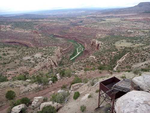
As we continued, the road got worse; or rather, it got worse from the point of view of a car driver, as it turned into a legit 4WD road, strewn with boulders and bumps and steep ups and downs. For mountain bikes, it was about perfect, and the last four miles or so were really fun. The roads here were put in for radium, uranium, and vanadium mining - this area is now a US Department of Energy Uranium Reserve, in that the mining was mostly discontinued but is available in case of need - and the Wedding Bell Hut is near a closed mine. Lots of junk from the mining era (1910-1922, and then again from 1935 through the early 1960s) is still scattered across the plateau.


Today's ride had been relatively easy and took us only about four hours, so we had a lot of time to explore and/or sit on the deck looking at the scenery and drinking alas only somewhat cool beer. I made a big pot of what we dubbed Wedding Bell Pasta - spaghetti with canned tomatoes, mushrooms, olives, and chicken, all swirled around with olive oil, oregano, and basil - and we went to bed.
Day 5: Wedding Bell Hut to Paradox Valley Hut
32.3 miles, 3100' ascent, 4190' descent, max elevation 6990', min 4950'
Dave and Brian tend to snore a lot, so they had set up their beds outside. But around two a.m. the skies opened up again, chasing them inside. It rained hard for some time, so in the morning we took
our time getting ready to go, hoping the roads would dry out. Unfortunately, as with the previous day there wasn't that much sun, and more storms were expected in the afternoon, so we headed out around 9:30 hoping that things weren't too bad. (Spoiler alert: At first they weren't. Then they were worse.)
The old mining roads wound up and down and around the tortured terrain. Steep rocky uphills were interspersed with steep rocky downhills, and great views all around. We quickly learned, however, to avoid the streaks of greenish-white dirt, as they had been transformed by the night's rain into a thick mud that clung tenaciously to our tires. There were only a few stretches of this on the road, though, and as we headed up the day's last big climb - 500 feet in 1.2 miles up to the Davis Mesa - we foolishly thought we'd dodged the mud bullet. (Spoiler alert: HAHAHAHA.)


As we climbed to Davis Mesa, the thunderstorms rolled in. Dark clouds and lightning ahead of us on the mesa, dark clouds and lightning behind us, pouring rain on the roads we'd ridden that morning and the ones we were headed for. Fortunately we all made the top of the climb before it started raining where we actually were; we pulled on our rain gear, ducked under the largest tree we could find, and waited it out while we ate lunch.
It was still sprinkling when we got underway again, so we left the rain gear on. The road across the top of Davis Mesa had gone back to the same red clay dirt that we'd hit in the Dry Creek Basin, which made us nervous, as it was damp with the earlier rain and the mud began to accumulate on our bikes. Still, it wasn't impassable, just a little messy, so as long as we didn't get nailed by another thunderstorm we figured we might be okay.
No such luck. When the clouds broke open, we did our best to huddle under the scrawny juniper trees, but we all got soaked, and so did the road. When we set out again, the road had turned into a gloppy, slippery mess. Impassable when wet? Try impossible! The mud caked onto the tires so thickly that it quickly clogged the forks, bringing the wheels to a halt within a few yards. Mud on the chain and gears meant no shifting was possible. The only way to proceed was to coast downhill or pedal in whatever gear one happened to be in, and try to keep upright, no small task on the nearly frictionless surface. I couldn't even push the bike because my feet slid with every step.


Finally we all managed to coast, push, or carry our bikes to our breaking point. We had covered maybe two miles in three hours. It was miserable. We were miserable. Glumly we regrouped, snacked, and cleaned our bikes as best as we could.
Meanwhile, it finally stopped raining. The road surface began to harden - or maybe it was just that we'd made it past the worst of the clay. (I suspect a little of both. Note to self: when it rains, WAIT AND LET THE MUD DRY.) We carefully coasted until it seemed safe to try to pedal and (gently) shift gears. All of our bikes worked enough to ride, though none of them worked particularly well. That was okay: we knew we'd be carrying them soon enough.
You see, at the end of the Davis Mesa is a bit of singletrack called the Catch-em-up Trail (also "Ketch-m-up" and "Ketchump" and other variations, depending on which map you have), which is listed in the cue sheet as a mandatory hike-a-bike. The road got rockier and narrower (and harder to follow - we got off-track once) and finally turned into a lovely singletrack, on which we were able to ride all of a few hundred yards before it plunged off the end of the mesa. 1000' vertical in one rocky mile, more or less. Eep!


The singletrack at the bottom of the plunge was rideable enough, though, and then we had eight miles of mostly-gravel road to get to the hut as the sun approached the horizon. The air seemed to consist largely of tiny little bugs, which flew into my mouth and up my nostrils and into my eyes. It was insult added to injury, and when Brian came up alongside me and commiserated, I told him I was counting on the ice-cold beer that surely awaited us in the hut. "I'd even drink PBR, if it was cold," I said. "But of course there will be some cold Fat Tire waiting for us, right?"
Brian allowed as how I was probably delusional, but when we got to the hut - surprise! It must have been recently re-stocked, for not only was the beer cooler full of delicious cold beverages (including the good stuff), a third small cooler nestled next to the eggs/cheese and beer coolers, filled with fresh cucumbers, beets, and carrots, with a note saying they were courtesy of Marty and Greg at the Paradox Store. Dave cut up some cucumbers with olive oil, salt, and pepper as an appetizer which we greedily gobbled up with our cold beer, but for dinner? It was 8pm (so much for our 6-hour riding time! The day had been 10.5 hours long!), we were filthy and exhausted - we opened a bunch of cans of beef stew, and that was just fine.
Day 6: Paradox Valley Hut to Geyser Pass Hut
24.5* miles, 5370' ascent, 1010' descent, min elevation 5344' (PV hut), max 9750' (GP Hut)
(Mileage is best guess of the rain/less mud alternate route; total ascent/descent is probably slightly less, but still a whole lot of climbing.)
Truly impressive thunderstorms swept the valley that night, but despite the hard rain, our bikes were still pretty much as muddy in the morning as they had been that evening. We decided that our best course of action would be to ride to the Paradox Store to see if they had a hose we could use to clean off the mud, so we limped into what passed for downtown Paradox. As we rode by a red house, the woman in the garden called out, "Oh, good, you made it, we were worried!" Turned out this was Marty, owner of the store, who had stocked the cold beer and vegetables the previous afternoon. The store, a few houses over, wasn't open yet, but she walked over with us and hooked up a hose so we could de-mud-ify our bikes. After thanking her and Greg profusely, we rode a few miles to dry out our bikes' drivetrains, then stopped to oil them up. The difference was amazing. We could ride again!

Because of the recent rain, we decided to do the alternate route up the end of Paradox Valley rather than the Carpenter Ridge Road. This route is paved in the lower section before turning to gravel, but after our experience on Davis Mesa we didn't want to risk any more red clay dirt roads! We steadily climbed the steep switchbacks, stopping periodically to re-oil our chains. Around us the scenery changed from redrock high desert to ponderosa forest as we ascended the 2300 feet to Buckeye Reservoir, which was more or less our halfway point in terms both of distance and climb.
As we approached the reservoir, it began to rain. Fortunately the road, while dirt and gravel, was still pretty good, and mud wasn't an issue. We huddled under a tree in the picnic area, eating our lunches and layering up against the cold and rain. Then we girded our loins for the long climb ahead of us.
From Buckeye Reservoir, it was just over a mile to the state line. We'd ridden our bicycles all the way to Utah!

The state line also marked our crossing onto private property, the huge Redd Ranch. Up until then we'd seen a few scattered vehicles on the roads; now we saw nobody other one guy (a ranch worker or guest) on an ATV. The road became a little narrower and rockier, and the scenery became spectacular. None of us had spent any time on the east side of the La Sal mountains, but we were all impressed by their beauty, especially as the skies began to clear.
The road wound up and down (though mostly up), through tree-covered hills and meadows full of cows. Eventually, though, we turned off onto a primitive double-track, rocky and uphill with occasional pockets of mud and nasty steep sections. This was slow going, which made us easy targets for the swarms of mosquitoes, at least until we stopped to slather ourselves with bug dope. It seemed unfair that the last 2.5 miles of a long day should be the hardest technical challenge! But finally we reached the hut - our last hut of the trip - and enjoyed our well-earned beers while watching the beautiful sunset.


Day 7: Geyser Pass Hut to Moab
33.6* miles, 2142' ascent, 7473' descent, max elevation 10,570', min 4140' (Moab)
(Mileage is best guess of the standard route plus the UPS trail variation.)
The day started with more uphill. After a couple of miles of hard work, we emerged onto public land; the road surface improved, and the grade got less steep. Another mile, and we were at the pass!


From here there were several singletrack options, but after having done our research we decided they would be pushing our skill level even if we hadn't been exhausted after a week of hard riding, so we stuck to the dirt road descent, nearly nine miles of screaming downhill heading out of the forest and toward the desert.

At this point the road, which had turned to pavement, hit a T-intersection, where we turned right. And uphill. Six miles worth of uphill, ugh! Four miles into it, Sand Flats Road came off on the left, and Dave and Scott peeled off to take this shortcut as they'd be meeting Dave's wife early in the afternoon, who'd take them back to Durango; Dave's not a fan of Moab, especially not in the heat of summer. And it certainly was hot! The cloudy, rainy weather that had plagued us all week had vanished. The sky was blue, and the mercury was well above 90°F, though the high temperature of 99° that day was much less than the 111° that had been in the forecast when we'd left Durango!
A few miles later, the rest of us turned left onto the Kokopelli Trail, an easy singletrack descent. After a leisurely lunch in the shade by the side of the trail, we coasted downhill until we hit the turnoff for the UPS (Upper Porcupine Rim) trail, which was pretty much the only optional singletrack we thought would be within our ability. Which it barely was! I think if we hadn't had loaded bikes and a week's worth of accumulated fatigue it would have been a lot easier; as it was, I walked a few of the slickrock climbs and descents, and was pretty nervous on a few that I tackled on the bike, though I only fell a couple of times (none badly).
A worse casualty of the accumulated fatigue was Brian's rear rack. After one fall he noticed that something was dragging on his rear tire. When we all stopped to inspect his bike, we saw that his rack had sheared completely through! We rigged straps so he could carry one of his panniers as a backpack, and split up the rest of his gear. The broken rack we hung in a tree because we couldn't figure out how to carry it out - hopefully some nice person has cleaned up our mess, sorry!


After the three-mile-long UPS, we bailed back onto the Sand Flats road rather than attempt the much harder Porcupine Rim trail. But it was super-scenic, and after the 4WD section gave way to an easy dirt road we could even look around and enjoy the view. We rode past red sandstone formations and the famous Slickrock trail system (which was mostly empty, because 99°) and finally into Moab, where we had celebratory beers at Eddie McStiff's (sitting outside on the patio, because I'm sure we stank) and then rode to the condo we'd rented for the night (and showers!!!!).

In the morning our shuttle driver picked us up and we headed back to Purgatory to pick up Glenn's van. Needless to say, the return trip was much faster and less strenuous than the outbound journey had been - but it was a heck of a lot less fun!
All the photos (119!), none of the blahblah
Advice I'd give to anyone contemplating this trip
Or you can bike there in seven arduous days, over 215 miles of secondary roads, jeep roads, and trails, up mountains and across desert valleys along the route set up by San Juan Huts. (Here is a map Britt put together, showing the route - click "->7.5' Topo Maps" and zoom in to see it more clearly.)
Want to guess what we did? Yeah. Strenuous climbs, scary descents, rain, heat, mud, and mosquitoes - also killer views, deserted roads, and cold beers enjoyed with good friends. I call it a win.
Day 1: Purgatory to Bolam Pass Hut
18 miles, 3725' ascent, 1310 descent, max elevation 11,420 (Bolam Pass), min 8870'
The route actually starts at Purgatory ski resort, which is another 25 minutes up the road from town. Our friend (and also Britt's business partner) Glenn had driven in from California with his adventure-racing partner Brian, and he drove the four of us and our gear to the ski area parking lot.
We started out on the gravel road leading out of the ski resort parking lot. It's a decent road but steep, and it switchbacks up over 900 feet in less than three miles...then in the next six miles it drops to a little below the start point, and crosses Hermosa Creek, which is shallow but wide and very, very rocky. All of us got our feet wet, and Glenn a bit more...
We had lunch in a beautiful meadow shortly after crossing the creek. At this point, the road changed character, getting ever steeper, rockier, and narrower. You'd definitely want a 4WD high-clearance vehicle - or a mountain bike! We forded numerous small creeks and powered over rocky shelves as we climbed toward the summit of Bolam Pass. I was quite happy with my climbing ability; I'd been grumpy about Britt "making me" ride a lot of steep jeep roads over the past month, but the training definitely paid off.
The day had started with crystalline blue skies, but the forecast for the day - for the whole week - was not so sunny. According to NOAA, the afternoon would bring rapid thunderstorm development and a 60% chance of rain, possibly heralding the start of the southwest monsoon and the end of June's dry and sunny weather. It had been hard to believe as we had climbed in the hot sun and rested under fluffy white clouds, but seemingly between one switchback and the next, the weather changed. The sun hid behind dark gray overcast, and we heard the rumble of thunder. A few drops of rain hit us, then a few more, and suddenly it was pouring.
Luck was with us, though; just as the weather turned, we went around a switchback and found the Greysill Mine Historic Site, an old cabin which despite its disrepair still had a solid roof. We took shelter inside for half an hour or so, eating snacks and putting on warm layers and rain gear while hail rattled on the roof and lightning flashed in the skies. After the worst had passed and the rain had moderated, we continued to the pass. The views were somewhat shrouded by the clouds, but they were still impressive.
The turnoff for the hut was about a mile after the pass. The hut itself was a small green box-like cabin, but tired, wet, and cold as we were, it was Nirvana. Britt immediately set off to gather firewood to start the wood stove, while Glenn opened a few cans of chicken noodle soup from the copiously stocked cabinets and heated a pot on the propane stove. It was actually only about 2pm, but we pretty much napped the afternoon away; then I made a big pot of chicken and sweet potato curry with rice. Glenn had actually carried up two bottles of excellent wine, so we had quite a feast!
The huts are all more or less identical: two sets of bunks along the side walls, a countertop, propane stove, and cubbies for cookware and cleaning supplies along the far wall under a large window, and two floor-to-ceiling cabinets holding a huge supply of canned and packaged food, plus nonrefrigerated fresh stuff like apples, potatoes, and onions, on the wall with the entrance door. A large cooler holds eggs, bacon, cheese, and tortillas; a small cooler holds beer. There's a trash can and a recycle can, and a food scraps bucket to be mixed with the compost pile which is in a bear-proof container near the (also composting) outhouse. The mountain huts are green and have a wood stove, the desert huts are tan and have a ventilator fan, and the selection of cookware varied oddly - one hut had four can openers and another had only one, for example - but otherwise they're all basically the same. The huts sleep eight, but you get the whole place for the price of six riders, which is what we'd done; we'd have two more friends joining us at the third hut, but it felt quite comfortable with just the four of us.
Day 2: Bolam Pass Hut to Black Mesa Hut
29 miles, 3722' ascent, 4450' descent, max elevation 11,420 (Bolam Pass), min 8886', end 10,687'
The forecast for today had been for more afternoon thunderstorms, so in an attempt to avoid them we woke before 6am to a beautiful sunrise. Two hours later, after eating breakfast, making lunches, packing our stuff back onto our bikes, and cleaning the hut, we hit the road.
The other side of Bolam Pass was just as nasty and rocky as the one we'd come up - but at least we were going down! We set our shocks to max and bumped our way down for about seven miles, during which the road gradually improved. At the bottom we turned right onto a paved road for all of half a mile before taking a left onto another dirt road, which immediately started switchbacking uphill. This was a familiar route to Britt and me, at least in reverse, as we'd taken this Forest Service road on our way back from our climb of Lone Cone in 2014.
We climbed to some beautiful meadows, where we stopped for a snack. Unfortunately it was not just a snack for us: we became snacks to the myriad mosquitoes, so we made it a short break and continued on. A long downhill brought us to the Burro Bridge Forest Service campground, where we ate lunch and refilled our water supply. After another few miles of down, bringing us to the day's lowest elevation, we turned right and headed up again.
This was the road we had driven in our Sportsmobile to our base camp for climbing Lone Cone. It sure seemed steeper on bicycles! Though it was a good-quality dirt road - an ordinary car could drive it - it climbed relentlessly, and we gained 1365' in four miles. The afternoon thunderstorms had begun by now, as well, but somehow we managed to dodge them all; it seemed as though we were always heading toward the one patch of blue sky between thunderclouds. (Inspiring me to sing, "Clouds to the left of me, thunder to the right, here I am, stuck in the middle with you!")
The road finally leveled out and even lost a little elevation over the next few miles, but then we started another steep climb. We were all pretty exhausted by the time we found the unobtrusive side road that led to the hut, but oddly it turned out that the day's ride, though 11 miles longer than the previous day, had taken more or less the same amount of time, about six hours. The mosquitoes around the hut were vicious, and we quickly let ourselves inside. Which was when the thunderstorms finally caught up with us - but we didn't care, we were warm and dry!
Day 3: Black Mesa Hut to Dry Creek Basin Hut
35.2 miles, 2061' ascent, 5457' descent, max elevation 11,066, min 7234' (DCB hut)
It rained quite a lot that night, which was a concern because the cue sheet of directions provided by SJHS mentioned a "potentially very muddy" section of road. We made the decision to sleep in, have a big breakfast, and leave late in the morning after (hopefully) things had dried out a bit, and we crossed our fingers we wouldn't get caught in afternoon storms.
The dirt road continued uphill past the hut. After a while it got rockier and narrower, but hey, we were on mountain bikes. After just under eight miles, we broke away from the road onto an even rockier, narrower jeep trail, which climbed a short distance to a pass, then stretched out in a long descent below us. This was the bit of the route we'd worried about, but though there were quite a few puddles we had to avoid, the track was rocky enough that the mud wasn't an issue. We bumped and bounced over the rocks, swerved around the puddles and mud, and feasted our eyes on the green meadows and lush trees of the Uncompaghre National Forest.
Finally we hit an actual road, though it was still gravel-surfaced, and it took us out of the last bit of the mountains (though we could still see Lone Cone looming above us) and toward a broad valley in which sat Miramonte Reservoir, which is part of the Dan Noble State Wildlife Area. We'd been excited about passing this lake for two reasons: first, we hoped to refill our water bottles at the campground there, and second, we hoped to wash off our accumulated load of sweat, sunscreen, and bug dope. Alas, we didn't find drinking water, but we did find a small rocky beach that was somewhat hidden from view of both the campground and the road. The day had clouded over, but it hadn't actually started to rain yet, so we walked down to the water, stripped off our sweaty clothes, and did a little skinny-dipping.
When we emerged, somewhat cleaner and re-clothed, and climbed back up to our bikes, a big white truck with an official Colorado Parks and Wildlife seal on the door cruised up to us. Uh-oh, we thought. Busted! But it turned out that the older couple in the truck, seasonal volunteers, just wanted to offer us bottled water, which we gladly accepted.
From the reservoir, our road snaked upward again. We stopped at the top of "Sandy's Fort Pass" to take photos, as well as take advantage of the rare availability of cell phone service on the route; then we put on our rain gear, as the stormy skies had decided to make good on their threat of rain. A 4.3-mile downhill took us to the private doubletrack that led to the hut, where our neighbor Dave and his friend Scott were waiting; Dave's wife had driven them from Durango to the reservoir earlier that day, and they'd ridden from there. They were wondering if something happened to us, since we arrived so late, but of course, we were late because we'd started late. As it turned out, yet again we had again spent roughly six hours getting from one hut to the next.
Day 4: Dry Creek Basin Hut to Wedding Bell Hut
33.5* miles, 2500' ascent, 3320' descent, max elevation 7294' (DCB hut), min 6301'
(Mileage is for standard route, our route was probably a little shorter.)
It rained more that evening and night, and the decision was made to "dawdle" again in the morning to allow the muddy parts of the route to dry out. But the morning was overcast, with no sun to accelerate the drying process, and the forecast was for more rain in the afternoon, so we didn't dawdle too much. Instead we set out on the "Rain/Less Mud Alternate" which was a graveled road, as the red clay dirt roads of western Colorado and eastern Utah are (as the sign says) "Impassable When Wet". When we hit the paved highway, we realized that the singletrack option that we'd hoped to take would have required five miles on the highway first, and nobody wanted to do that - so instead we crossed the road to take the standard route on a network of red clay dirt farm roads, since they seemed dry enough now, and we figured that we could angle over to the singletrack at a later spot that had been marked on our maps.
Unfortunately, later in the morning, it began to drizzle. Fortunately, the farm roads didn't seem too muddy despite the warning in the cue sheet. Unfortunately, when we hit the connector that would take us to the singletrack option, it was not a road but a muddy doubletrack across the grass. So we stayed on the farm roads. No big deal, as there was nearly no traffic and we managed to dodge any big rainstorms that might have turned the roads sloppy, but of course we missed out on the singletrack.
After passing the connector the road slowly climbed out of the farms, as ahead of us the red-rock walls of the Big Gypsum Valley and the Dolores River canyon began to come into view, and the road got rockier, less red-clay muddy and far more scenic. We took a lunch break under a huge tree - the cue sheet noted it as a good place for a shady break, but for us it was a rain cover - and by the time we'd finished, the drizzle had stopped and the sun was peeking from behind the clouds.
As we continued, the road got worse; or rather, it got worse from the point of view of a car driver, as it turned into a legit 4WD road, strewn with boulders and bumps and steep ups and downs. For mountain bikes, it was about perfect, and the last four miles or so were really fun. The roads here were put in for radium, uranium, and vanadium mining - this area is now a US Department of Energy Uranium Reserve, in that the mining was mostly discontinued but is available in case of need - and the Wedding Bell Hut is near a closed mine. Lots of junk from the mining era (1910-1922, and then again from 1935 through the early 1960s) is still scattered across the plateau.
Today's ride had been relatively easy and took us only about four hours, so we had a lot of time to explore and/or sit on the deck looking at the scenery and drinking alas only somewhat cool beer. I made a big pot of what we dubbed Wedding Bell Pasta - spaghetti with canned tomatoes, mushrooms, olives, and chicken, all swirled around with olive oil, oregano, and basil - and we went to bed.
Day 5: Wedding Bell Hut to Paradox Valley Hut
32.3 miles, 3100' ascent, 4190' descent, max elevation 6990', min 4950'
Dave and Brian tend to snore a lot, so they had set up their beds outside. But around two a.m. the skies opened up again, chasing them inside. It rained hard for some time, so in the morning we took
our time getting ready to go, hoping the roads would dry out. Unfortunately, as with the previous day there wasn't that much sun, and more storms were expected in the afternoon, so we headed out around 9:30 hoping that things weren't too bad. (Spoiler alert: At first they weren't. Then they were worse.)
The old mining roads wound up and down and around the tortured terrain. Steep rocky uphills were interspersed with steep rocky downhills, and great views all around. We quickly learned, however, to avoid the streaks of greenish-white dirt, as they had been transformed by the night's rain into a thick mud that clung tenaciously to our tires. There were only a few stretches of this on the road, though, and as we headed up the day's last big climb - 500 feet in 1.2 miles up to the Davis Mesa - we foolishly thought we'd dodged the mud bullet. (Spoiler alert: HAHAHAHA.)
As we climbed to Davis Mesa, the thunderstorms rolled in. Dark clouds and lightning ahead of us on the mesa, dark clouds and lightning behind us, pouring rain on the roads we'd ridden that morning and the ones we were headed for. Fortunately we all made the top of the climb before it started raining where we actually were; we pulled on our rain gear, ducked under the largest tree we could find, and waited it out while we ate lunch.
It was still sprinkling when we got underway again, so we left the rain gear on. The road across the top of Davis Mesa had gone back to the same red clay dirt that we'd hit in the Dry Creek Basin, which made us nervous, as it was damp with the earlier rain and the mud began to accumulate on our bikes. Still, it wasn't impassable, just a little messy, so as long as we didn't get nailed by another thunderstorm we figured we might be okay.
No such luck. When the clouds broke open, we did our best to huddle under the scrawny juniper trees, but we all got soaked, and so did the road. When we set out again, the road had turned into a gloppy, slippery mess. Impassable when wet? Try impossible! The mud caked onto the tires so thickly that it quickly clogged the forks, bringing the wheels to a halt within a few yards. Mud on the chain and gears meant no shifting was possible. The only way to proceed was to coast downhill or pedal in whatever gear one happened to be in, and try to keep upright, no small task on the nearly frictionless surface. I couldn't even push the bike because my feet slid with every step.
Finally we all managed to coast, push, or carry our bikes to our breaking point. We had covered maybe two miles in three hours. It was miserable. We were miserable. Glumly we regrouped, snacked, and cleaned our bikes as best as we could.
Meanwhile, it finally stopped raining. The road surface began to harden - or maybe it was just that we'd made it past the worst of the clay. (I suspect a little of both. Note to self: when it rains, WAIT AND LET THE MUD DRY.) We carefully coasted until it seemed safe to try to pedal and (gently) shift gears. All of our bikes worked enough to ride, though none of them worked particularly well. That was okay: we knew we'd be carrying them soon enough.
You see, at the end of the Davis Mesa is a bit of singletrack called the Catch-em-up Trail (also "Ketch-m-up" and "Ketchump" and other variations, depending on which map you have), which is listed in the cue sheet as a mandatory hike-a-bike. The road got rockier and narrower (and harder to follow - we got off-track once) and finally turned into a lovely singletrack, on which we were able to ride all of a few hundred yards before it plunged off the end of the mesa. 1000' vertical in one rocky mile, more or less. Eep!
The singletrack at the bottom of the plunge was rideable enough, though, and then we had eight miles of mostly-gravel road to get to the hut as the sun approached the horizon. The air seemed to consist largely of tiny little bugs, which flew into my mouth and up my nostrils and into my eyes. It was insult added to injury, and when Brian came up alongside me and commiserated, I told him I was counting on the ice-cold beer that surely awaited us in the hut. "I'd even drink PBR, if it was cold," I said. "But of course there will be some cold Fat Tire waiting for us, right?"
Brian allowed as how I was probably delusional, but when we got to the hut - surprise! It must have been recently re-stocked, for not only was the beer cooler full of delicious cold beverages (including the good stuff), a third small cooler nestled next to the eggs/cheese and beer coolers, filled with fresh cucumbers, beets, and carrots, with a note saying they were courtesy of Marty and Greg at the Paradox Store. Dave cut up some cucumbers with olive oil, salt, and pepper as an appetizer which we greedily gobbled up with our cold beer, but for dinner? It was 8pm (so much for our 6-hour riding time! The day had been 10.5 hours long!), we were filthy and exhausted - we opened a bunch of cans of beef stew, and that was just fine.
Day 6: Paradox Valley Hut to Geyser Pass Hut
24.5* miles, 5370' ascent, 1010' descent, min elevation 5344' (PV hut), max 9750' (GP Hut)
(Mileage is best guess of the rain/less mud alternate route; total ascent/descent is probably slightly less, but still a whole lot of climbing.)
Truly impressive thunderstorms swept the valley that night, but despite the hard rain, our bikes were still pretty much as muddy in the morning as they had been that evening. We decided that our best course of action would be to ride to the Paradox Store to see if they had a hose we could use to clean off the mud, so we limped into what passed for downtown Paradox. As we rode by a red house, the woman in the garden called out, "Oh, good, you made it, we were worried!" Turned out this was Marty, owner of the store, who had stocked the cold beer and vegetables the previous afternoon. The store, a few houses over, wasn't open yet, but she walked over with us and hooked up a hose so we could de-mud-ify our bikes. After thanking her and Greg profusely, we rode a few miles to dry out our bikes' drivetrains, then stopped to oil them up. The difference was amazing. We could ride again!
Because of the recent rain, we decided to do the alternate route up the end of Paradox Valley rather than the Carpenter Ridge Road. This route is paved in the lower section before turning to gravel, but after our experience on Davis Mesa we didn't want to risk any more red clay dirt roads! We steadily climbed the steep switchbacks, stopping periodically to re-oil our chains. Around us the scenery changed from redrock high desert to ponderosa forest as we ascended the 2300 feet to Buckeye Reservoir, which was more or less our halfway point in terms both of distance and climb.
As we approached the reservoir, it began to rain. Fortunately the road, while dirt and gravel, was still pretty good, and mud wasn't an issue. We huddled under a tree in the picnic area, eating our lunches and layering up against the cold and rain. Then we girded our loins for the long climb ahead of us.
From Buckeye Reservoir, it was just over a mile to the state line. We'd ridden our bicycles all the way to Utah!
The state line also marked our crossing onto private property, the huge Redd Ranch. Up until then we'd seen a few scattered vehicles on the roads; now we saw nobody other one guy (a ranch worker or guest) on an ATV. The road became a little narrower and rockier, and the scenery became spectacular. None of us had spent any time on the east side of the La Sal mountains, but we were all impressed by their beauty, especially as the skies began to clear.
The road wound up and down (though mostly up), through tree-covered hills and meadows full of cows. Eventually, though, we turned off onto a primitive double-track, rocky and uphill with occasional pockets of mud and nasty steep sections. This was slow going, which made us easy targets for the swarms of mosquitoes, at least until we stopped to slather ourselves with bug dope. It seemed unfair that the last 2.5 miles of a long day should be the hardest technical challenge! But finally we reached the hut - our last hut of the trip - and enjoyed our well-earned beers while watching the beautiful sunset.
Day 7: Geyser Pass Hut to Moab
33.6* miles, 2142' ascent, 7473' descent, max elevation 10,570', min 4140' (Moab)
(Mileage is best guess of the standard route plus the UPS trail variation.)
The day started with more uphill. After a couple of miles of hard work, we emerged onto public land; the road surface improved, and the grade got less steep. Another mile, and we were at the pass!
From here there were several singletrack options, but after having done our research we decided they would be pushing our skill level even if we hadn't been exhausted after a week of hard riding, so we stuck to the dirt road descent, nearly nine miles of screaming downhill heading out of the forest and toward the desert.
At this point the road, which had turned to pavement, hit a T-intersection, where we turned right. And uphill. Six miles worth of uphill, ugh! Four miles into it, Sand Flats Road came off on the left, and Dave and Scott peeled off to take this shortcut as they'd be meeting Dave's wife early in the afternoon, who'd take them back to Durango; Dave's not a fan of Moab, especially not in the heat of summer. And it certainly was hot! The cloudy, rainy weather that had plagued us all week had vanished. The sky was blue, and the mercury was well above 90°F, though the high temperature of 99° that day was much less than the 111° that had been in the forecast when we'd left Durango!
A few miles later, the rest of us turned left onto the Kokopelli Trail, an easy singletrack descent. After a leisurely lunch in the shade by the side of the trail, we coasted downhill until we hit the turnoff for the UPS (Upper Porcupine Rim) trail, which was pretty much the only optional singletrack we thought would be within our ability. Which it barely was! I think if we hadn't had loaded bikes and a week's worth of accumulated fatigue it would have been a lot easier; as it was, I walked a few of the slickrock climbs and descents, and was pretty nervous on a few that I tackled on the bike, though I only fell a couple of times (none badly).
A worse casualty of the accumulated fatigue was Brian's rear rack. After one fall he noticed that something was dragging on his rear tire. When we all stopped to inspect his bike, we saw that his rack had sheared completely through! We rigged straps so he could carry one of his panniers as a backpack, and split up the rest of his gear. The broken rack we hung in a tree because we couldn't figure out how to carry it out - hopefully some nice person has cleaned up our mess, sorry!
After the three-mile-long UPS, we bailed back onto the Sand Flats road rather than attempt the much harder Porcupine Rim trail. But it was super-scenic, and after the 4WD section gave way to an easy dirt road we could even look around and enjoy the view. We rode past red sandstone formations and the famous Slickrock trail system (which was mostly empty, because 99°) and finally into Moab, where we had celebratory beers at Eddie McStiff's (sitting outside on the patio, because I'm sure we stank) and then rode to the condo we'd rented for the night (and showers!!!!).
In the morning our shuttle driver picked us up and we headed back to Purgatory to pick up Glenn's van. Needless to say, the return trip was much faster and less strenuous than the outbound journey had been - but it was a heck of a lot less fun!
All the photos (119!), none of the blahblah
Advice I'd give to anyone contemplating this trip
- Reserve the whole hut. They are not very big, and I think they'd be tough to share with other groups.
- ETA: have a GPS, or phone GPS app and spare batteries. The route is not always obvious.
- Get in shape. Train with the type of riding you'll be doing on this trip, that is, jeep roads with lots of elevation gain. The fitter you are the happier you'll be.
- Most important thing about the bike is that it should be in good repair. Details don't matter: among the six of us we spanned all the wheel sizes and all the gearing set-ups, and one guy rode a hardtail. I was happy with my Pivot Mach 4, 27.5" wheels and a 1x11. Of course, bring tools and spare parts to fix things, and the knowledge to use them. Most of our repairs were maintenance-type things, e.g. oiling, cleaning, adjusting.
- Pack light but pack well. I brought: rain jacket, rain pants, fingerless gloves, full-finger gloves, Gore-Tex glove covers, hut shorts, hut t-shirt, hut bra, hut socks, hut shoes (light rubber slip-ons), hut underwear x2, thin fleece, down sweater (these two items also served as my pillow, which the huts don't provide), cap, riding shorts, lined tights, long-sleeved riding shirt, chamois x2, sportsbra x2, short-sleeved riding shirt x2, and riding socks x3. I used everything. My original plan was to rinse out one set of riding clothes plus one underwear each day in a stream or lake (while wearing the other), but I only managed to do this three times due to weather, lack of water, lack of time, etc.
- Bring one or several small containers for packing lunch. The huts provide foil and baggies, but it was nice to e.g. make a tuna salad in advance and be able to carry it separately from the bread so the bread didn't get soggy.
- If it rains and you are on clay dirt or other potentially muddy roads/trails, wait it out if at all possible.