some Arizona and Utah vacationing
Apr. 8th, 2026 03:59 pmWinter in Durango was a bust this year; we got in one ski day, which was okay but not great, and although we were able to do much more mountain biking than usual in northern NM, on the trail systems about an hour's drive away - these are, well, an hour's drive away. (The Durango trails tend to get some snow and therefore be muddy in the winter, though by late February we were still able to ride on some that had melted out early.) As a result, we started plotting a van camping trip to Arizona and Utah to get some more riding in. Because of Britt's knee replacement last year and my own back issues, we hadn't done a van camping trip in a while, so we felt we were about due!
Britt booked a hotel room for a few nights in Sedona, where we have long wanted to try the mountain biking but never been able to find a place to camp, and reserved four nights at the campground in McDowell Mountain Park in Scottsdale, where we usually bike while staying in a VRBO at Thanksgiving. Then the plan was to drive to Gooseberry Mesa, near St. George Utah, where we rode once in 2008 (spoiler alert: we didn't actually make it this year), and then work our way back across southern Utah and ride other trail systems we'd found on our Trailforks map.
Unfortunately a large prescribed burn and a small wildfire near Flagstaff had sent quite a bit of smoke into the area, so when we set off the next morning from our hotel - we could get into the trail system from our hotel, which is one reason Britt chose it - the air was less than perfect. Still, it was a blue-sky day and Sedona's got a pretty backdrop:

The trails were surprisingly rough - a lot of rocks, and a lot of ups and downs. Just riding the four mile access to the loop we had planned took 1.3 hours! Also, the end of March in the western US was record-breakingly hot, and I do not do well in heat. (When I'm riding by myself I go out quite early, but one must make allowances for riding with one's spouse!) As a result, we did not feel like eating any more of our lunch than the apple we had to share, and we were so beat by the time we got back to the loop's trailhead (and it was so late, and hot) that there was no way we were going to retrace our route back to the hotel. Instead Britt found a coffee shop that we could reach by back roads, and we rode there and sat in the air conditioning and drank prickly pear lemonade (me) and a smoothie (him) and ate cake, and that was our lunch (at 2:30pm). Then we drank more water and made our way (again on roads) back to the hotel.


(These pictures make it look like a nice trail! It was not a nice trail! It was rocky and had a lot of tricky spots and we didn't like it much - though wow, it is amazing how the city recedes and it feels like you're just out in the woods somewhere.)
The next day we were pretty exhausted and burned out on the heat, so it was pretty easy to make the decision to ditch riding for...the Sedona No Kings rally! We had felt bad about missing our local march - we've really enjoyed attending these - so it was great to have an alternative. As we talked to the people around us, we discovered that many other tourists had the same idea, and the organizers might have anticipated this (Sedona's very much a tourist town) because they'd set out a large number of loaner signs. We each picked one up and joined the crowd in the high school parking lot; then we walked about a mile on the sidewalk along the main road, waving at drivers who honked and waved back (for the most part - we did get a very few "waves" of the middle finger) to the library, where various local politicians gave inspiring short speeches.


We walked back to the parking lot where we'd left our van, stopping for a cold drink at the same coffee shop that had rescued us before, and then drove south to Scottsdale.
The heat hadn't let up, and didn't look likely to do so, so we had decided to cancel our camping reservations and book an Air B&B instead. The place we found was an easy ride to the McDowell Sonoran Preserve, and if you have been reading this journal for a while you know we love that place! For the past 5+ years we've been renting a large VRBO in this part of Arizona at Thanksgiving and inviting friends to join us, so it had been a while since we'd been here in the springtime. But the great thing about going in the spring is - flowers!


Again, though, it was ludicrously hot, so we made an effort to get out to ride early. The first two mornings we rode at the McDowell Sonoran Preserve; on the third, we drove to the McDowell Mountain Park (yes, everything there is named for the (Union) civil war general Irvin McDowell, who actually never set foot in Arizona Territory) for our ride.


In the afternoons we...met up with realtors to look at houses, which I'm kind of embarrassed to admit, because, am I the sort of person who has a second house?!?! Well, considering how frequently we go to this area for biking, and how dreary Colorado winters are getting to be with not enough snow for skiing but too much cold and rain for mountain biking - and climate change means this trend is not likely to reverse - we are very seriously contemplating doing the snowbird thing. We didn't find anything we loved, but we are planning to continue to look, and seriously contemplate. We shall see!
Anyway! After a few days I started feeling restless; after all, though we had specifically wanted to do a van camping trip, we had not yet actually camped in the van. So on April 1 we loaded back up and drove north, stopping at the Glen Canyon Dam visitor's center in Page AZ to gawk at the very low water level (and use the bathroom) before heading north and west into Utah. One amusing thing about the drive was that it took us through Arizona and various tribal reservations, and then in Utah the road was barely north of the state line. This meant that the phone tower signals that our phones use to set the time of day were sometimes coming from Arizona, which uses Mountain Standard Time year-round, and sometimes from Utah or Arizona reservations, which switch to Mountain Daylight Time in the summer, so our phone time-of-day displays were constantly swapping an hour back and forth, when which was very weird!
We pulled in to camp on a dirt road near Kanab UT, the access for one of the new MTB areas we'd found on the map, and had a nifty moon view:

The next morning we rode Tilted Mesa! The weather had cooled a little, and as well as being further north, this area sits at a higher elevation than the Arizona areas, so it was quite comfortable riding, as well as giving us new trails and scenery to enjoy. The trails are all fairly short, but they loop around and connect with each other in such a way that we were able to construct a 7-mile tour that only repeated one short section.

In terms of both difficulty and ecosystem, these trails reminded us of our local stomping grounds, and it was super fun to ride them, with just enough challenging bits. However, toward the end of the ride Britt noticed that his wheels were sticking rather than rotating freely, and when he investigated after we had returned to the van, he discovered that his brake pads were completely worn out. We didn't have an extra set with us, but we figured we could get some at a bike shop on the way out to Gooseberry Mesa.
Except it turned out that there is only one bike shop on the way to Gooseberry Mesa, in Kanab, and they are closed on Thursdays. There is also only one bike shop in Page, Arizona, and it had already closed for the day and would not open until Friday afternoon. We'd planned on driving back on Saturday anyway, so we decided we'd spend one more night out and come back on Friday.
We weren't too far from the Buckskin Gulch and Wire Pass trailheads. These are spectacular slot canyons which join together and eventually hit the Paria river, an excellent backpacking route we've done a few times before. Once we locked our bikes at the Buckskin Gulch trailhead, drove to Wire Pass, then hiked down that canyon and back up Buckskin, and rode our bikes back to the vehicle. But it had been a while since we'd last hiked there, so we decided to drive there, hike for a few hours, then find a camp spot nearby, and drive back to Durango the next day.
The trailhead had been expanded since the last time we'd been there, and there were way more people than we'd ever seen there before. But it was still the spectacularly beautiful slot canyon we remembered. We, uh, took a lot of pictures.


Pictographs at the confluence:

Patterns in the rock:


We camped on a side road and headed back the next morning, with a quick stop to hike the Hanging Gardens trail near the Glen Canyon Dam. (Which was a bit of a disappointment after the above!) In conclusion:

Britt booked a hotel room for a few nights in Sedona, where we have long wanted to try the mountain biking but never been able to find a place to camp, and reserved four nights at the campground in McDowell Mountain Park in Scottsdale, where we usually bike while staying in a VRBO at Thanksgiving. Then the plan was to drive to Gooseberry Mesa, near St. George Utah, where we rode once in 2008 (spoiler alert: we didn't actually make it this year), and then work our way back across southern Utah and ride other trail systems we'd found on our Trailforks map.
Unfortunately a large prescribed burn and a small wildfire near Flagstaff had sent quite a bit of smoke into the area, so when we set off the next morning from our hotel - we could get into the trail system from our hotel, which is one reason Britt chose it - the air was less than perfect. Still, it was a blue-sky day and Sedona's got a pretty backdrop:
The trails were surprisingly rough - a lot of rocks, and a lot of ups and downs. Just riding the four mile access to the loop we had planned took 1.3 hours! Also, the end of March in the western US was record-breakingly hot, and I do not do well in heat. (When I'm riding by myself I go out quite early, but one must make allowances for riding with one's spouse!) As a result, we did not feel like eating any more of our lunch than the apple we had to share, and we were so beat by the time we got back to the loop's trailhead (and it was so late, and hot) that there was no way we were going to retrace our route back to the hotel. Instead Britt found a coffee shop that we could reach by back roads, and we rode there and sat in the air conditioning and drank prickly pear lemonade (me) and a smoothie (him) and ate cake, and that was our lunch (at 2:30pm). Then we drank more water and made our way (again on roads) back to the hotel.
(These pictures make it look like a nice trail! It was not a nice trail! It was rocky and had a lot of tricky spots and we didn't like it much - though wow, it is amazing how the city recedes and it feels like you're just out in the woods somewhere.)
The next day we were pretty exhausted and burned out on the heat, so it was pretty easy to make the decision to ditch riding for...the Sedona No Kings rally! We had felt bad about missing our local march - we've really enjoyed attending these - so it was great to have an alternative. As we talked to the people around us, we discovered that many other tourists had the same idea, and the organizers might have anticipated this (Sedona's very much a tourist town) because they'd set out a large number of loaner signs. We each picked one up and joined the crowd in the high school parking lot; then we walked about a mile on the sidewalk along the main road, waving at drivers who honked and waved back (for the most part - we did get a very few "waves" of the middle finger) to the library, where various local politicians gave inspiring short speeches.
We walked back to the parking lot where we'd left our van, stopping for a cold drink at the same coffee shop that had rescued us before, and then drove south to Scottsdale.
The heat hadn't let up, and didn't look likely to do so, so we had decided to cancel our camping reservations and book an Air B&B instead. The place we found was an easy ride to the McDowell Sonoran Preserve, and if you have been reading this journal for a while you know we love that place! For the past 5+ years we've been renting a large VRBO in this part of Arizona at Thanksgiving and inviting friends to join us, so it had been a while since we'd been here in the springtime. But the great thing about going in the spring is - flowers!
Again, though, it was ludicrously hot, so we made an effort to get out to ride early. The first two mornings we rode at the McDowell Sonoran Preserve; on the third, we drove to the McDowell Mountain Park (yes, everything there is named for the (Union) civil war general Irvin McDowell, who actually never set foot in Arizona Territory) for our ride.
In the afternoons we...met up with realtors to look at houses, which I'm kind of embarrassed to admit, because, am I the sort of person who has a second house?!?! Well, considering how frequently we go to this area for biking, and how dreary Colorado winters are getting to be with not enough snow for skiing but too much cold and rain for mountain biking - and climate change means this trend is not likely to reverse - we are very seriously contemplating doing the snowbird thing. We didn't find anything we loved, but we are planning to continue to look, and seriously contemplate. We shall see!
Anyway! After a few days I started feeling restless; after all, though we had specifically wanted to do a van camping trip, we had not yet actually camped in the van. So on April 1 we loaded back up and drove north, stopping at the Glen Canyon Dam visitor's center in Page AZ to gawk at the very low water level (and use the bathroom) before heading north and west into Utah. One amusing thing about the drive was that it took us through Arizona and various tribal reservations, and then in Utah the road was barely north of the state line. This meant that the phone tower signals that our phones use to set the time of day were sometimes coming from Arizona, which uses Mountain Standard Time year-round, and sometimes from Utah or Arizona reservations, which switch to Mountain Daylight Time in the summer, so our phone time-of-day displays were constantly swapping an hour back and forth, when which was very weird!
We pulled in to camp on a dirt road near Kanab UT, the access for one of the new MTB areas we'd found on the map, and had a nifty moon view:
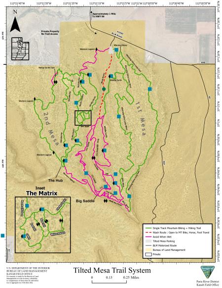
The next morning we rode Tilted Mesa! The weather had cooled a little, and as well as being further north, this area sits at a higher elevation than the Arizona areas, so it was quite comfortable riding, as well as giving us new trails and scenery to enjoy. The trails are all fairly short, but they loop around and connect with each other in such a way that we were able to construct a 7-mile tour that only repeated one short section.
In terms of both difficulty and ecosystem, these trails reminded us of our local stomping grounds, and it was super fun to ride them, with just enough challenging bits. However, toward the end of the ride Britt noticed that his wheels were sticking rather than rotating freely, and when he investigated after we had returned to the van, he discovered that his brake pads were completely worn out. We didn't have an extra set with us, but we figured we could get some at a bike shop on the way out to Gooseberry Mesa.
Except it turned out that there is only one bike shop on the way to Gooseberry Mesa, in Kanab, and they are closed on Thursdays. There is also only one bike shop in Page, Arizona, and it had already closed for the day and would not open until Friday afternoon. We'd planned on driving back on Saturday anyway, so we decided we'd spend one more night out and come back on Friday.
We weren't too far from the Buckskin Gulch and Wire Pass trailheads. These are spectacular slot canyons which join together and eventually hit the Paria river, an excellent backpacking route we've done a few times before. Once we locked our bikes at the Buckskin Gulch trailhead, drove to Wire Pass, then hiked down that canyon and back up Buckskin, and rode our bikes back to the vehicle. But it had been a while since we'd last hiked there, so we decided to drive there, hike for a few hours, then find a camp spot nearby, and drive back to Durango the next day.
The trailhead had been expanded since the last time we'd been there, and there were way more people than we'd ever seen there before. But it was still the spectacularly beautiful slot canyon we remembered. We, uh, took a lot of pictures.
Pictographs at the confluence:
Patterns in the rock:
We camped on a side road and headed back the next morning, with a quick stop to hike the Hanging Gardens trail near the Glen Canyon Dam. (Which was a bit of a disappointment after the above!) In conclusion: