five days in the Weminuche Wilderness
Jul. 5th, 2013 12:31 pm
The Weminuche is the largest wilderness (note to my non-US friends: this is a management designation) in Colorado, and it's pretty much directly outside our door (for certain values of 'directly outside'). Britt and I try to get there at least a couple of times a summer for backpacking or hiking. On this trip we were joined by our friends Mike, Shan, and Reggie.
We started from the Endlich Mesa trailhead, which is probably around 15 miles away as the crow flies, but 30 miles by road - and the last 10 are on a squiggly rough dirt road that takes an hour and a half to traverse. Luckily, our friend Jeff had come with us; he would hike with us a couple of miles, then hike back out and drive our van back. The rest of us would return on the Durango & Silverton Narrow Gauge Train.
Endlich Mesa is a long ridge that runs roughly south to north. We stopped for lunch at a place we could look over a saddle to the east and see the smoke of the West Fork Complex wildfire.


At the point where the ridge turns a bit to the east we descended along a small creek into the Florida River valley. This river is Durango's main water supply, and at the bottom of the valley is the city reservoir - no wonder our water tastes so delicious!

Then we climbed up the other side of the Florida valley to camp by Lake Marie. Looking back, we got lovely views of Mt Sheridan, which we climbed as part of our Labor Day weekend backpack last year. It looked quite spectacular in the alpenglow as well:

The next day Britt, Michael and I did a little day jaunt farther up the Florida River valley to the Castilleja Lakes, where Britt and I had camped on a backpack trip ten years ago. (I had always thought the name came from the fortification-like cliffs above the lakes, but while leafing through a wildflower guide before the trip I noticed that it is the Latin name for the Indian Paintbrush genus, which grows lavishly in this area.) Britt fished, Michael wandered, and I sat on rocks and read the second Brother Cadfael mystery on my e-reader. We kept an eye out for elk, but the only wildlife we saw were a few chipmunks, trout (in the lakes) and swarms of (fortunately non-biting) flies, which were just hatching out.

We returned to our campsite and I read some more, while Britt joined Shan in fishing for dinner in Lake Marie. Yum trout!
The next day we packed up our camp and climbed up above Lake Marie to Silver Mesa. This broad ridge is dotted with small lakes and potholes, as well as relics from exploratory mining (thus the name of the mesa) which ultimately did not pan out - a good thing, since this area would not have become wilderness if it had. Ordinarily there are amazing views to the south and west, but over the past few days the wildfire smoke had spread out through the area, and the visibility was sharply reduced from the usual.


We gradually ascended Silver Mesa to Trimble Pass, a high pass at nearly 13,000 feet. The trail on the other side stays high, contouring along rocky ridges and wildflower slopes almost to the far more heavily used Columbine Pass. We peeked over the edge into the top of Chicago Basin (where we'd go the next day) before continuing our high route well above Columbine Lake to the small unnamed pass that leads to Hazel Lake. We could see tents at Columbine Lake, and the tiny figures of people moving about, which would be the closest we'd come to seeing other human beings until the very last day of our hike.


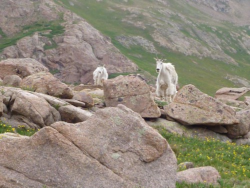
Hazel Lake is actually a set of two high lakes (around 12,450 ft) connected by a short rocky stream. It was jumping with fish, and we had a delicious trout dinner here as well. The basin is also the home to a small group of mountain goats, who took great interest in watching Britt fish.


And in watching us eat, and read, and hang out. And most especially in watching us pee, because they immediately move to lick up our urine for the salt and minerals. This was kind of cute at first, but then became rather obnoxious. On the other hand, we got to see mountain goats up close! They are a little odd-looking this time of year, because they are still shedding their winter coats, but still! Mountain goats!
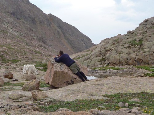
The next day we had a fairly short hike out of the basin and back to and over Columbine Pass, so we hung out fishing, reading, and watching the goats watch us until midday, and had lunch before heading out. Unfortunately this meant that we were high up on the trail just short of the pass when an early afternoon thunderstorm hit us. We quickly put on our rain gear and waited out the lightning and hail, then crossed the pass and descended into Chicago Basin. This is a very popular backpacking destination as it's the 'base camp' for climbing the three fourteeners (mountains over 14,000 feet) of Sunlight, Windom, and Aeolus, but we made our camp well above where the trail to the fourteeners branches off, and only saw a few other tents in the area. But what we did see (again) were mountain goats; in contrast to the billies around Hazel Lake, these were mostly nannies - and they had goatlets (all right, kids) with them, which are basically the most adorable things ever.

But they are getting out of hand. At one point I counted 26 goats, including five kids, in and around our camp!


In the morning we packed up and headed down Needle Creek, along with all the masses of people who had been camping in Chicago Basin. It was a bit of a shock to suddenly be among other human beings again - even more of a shock to see perhaps twice as many people hiking UP Needle Creek for the holiday week. (Since trailhead access is most usually done by a single daily train in each direction, once we started seeing hikers it was a fairly steady stream of them until we passed the last group.)
Now we were well below treeline, among the lush growth of the forest plants. The thimbleberry bushes were flowering, and there were a few ripe strawberries on the wild vines. (Were, I said. Because I plucked and ate them. :-) We arrived at the flag-stop for the train home well before its 3:35pm arrival, and settled in to wait with the rest of the hikers. As soon as we climbed aboard, we headed for the concession car and each of us bought a beer, to celebrate the successful conclusion of our backpacking trip!


These and more photos at Flickr, 36 in all
(no subject)
Date: 2013-07-05 09:09 pm (UTC)Have fun fishing in the Weminuche.
(no subject)
Date: 2013-07-05 11:05 pm (UTC)Isn't Endlich Mesa awesome! I work for a non-profit expedition camp called Cottonwood Gulch Foundation. I led a group of 15 (coed) teenagers on the Burnt timber/endlich mesa shuttle hike 2 years ago, spent 4 nights 5 days on the trail. Although the kids named the endless road the "death march". We parked the van half way up the road and hiked 4 miles of road on the way down from endlich mesa. I will never do that again....
Eric
(no subject)
Date: 2013-07-06 12:23 am (UTC)I don't remember how bad it was but our map shows a 2wd road until a sharp left at a creek crossing. I'm pretty sure we continued until the road bent right again, maybe to another creek crossing, but it was awful and so we parked and walked from there. We actually just angled uphill until we hit the trail, rather than going all the way to the trailhead.